Search This Blog

Saturday, December 28, 2013

Sloth Bear

Sloth Bear

One of animal it found on dry zone forest habitats in Sri lanka Sloth bear. It has thick coats and sickle like claws. This is the only member of the bare family found in Sri lanka. This animal have main problem the human encroach the there's living places.

වලසා

ශ්ශීලංකාෙව් වියලි කලාපීය වනාන්තරයන්හි දැකිය හැකි වලස් පවුලට අයත් ඒකම සාමාජිකයා. කලු ෙෙලා්ම වැස්මකින් සමන්විත ෙමම වලසා අාහාරයට ලනු ලබන්ෙන් ෙව්යන් හා පළතුරුය. ෙමම ජීවියාෙග් ජීවන චකයට මහත් භාධාවක් වන්ෙන් මිනිසුන් විසින් ඔවුන්ෙග් වාස භූමි අාකමණය කිරිමයි.


Wednesday, February 15, 2012

Kaudulla National Park


Kaudulla National Park is Situated about 190 km from Colombo, Kaudulla National Park is dominated by the Kaudulla Tank built by the sister of the famous King Mahasena who was the creator of the Minneriya Tank. The folklore of the creation of this tank is very interesting.
After the sister of the king Mahasena married a person disapproved by the king, she was banned from the palace and the newly married couple went off and established a small farming village around Kaudulla. Meanwhile King Mahasena while building and developing the irrigation systems around the country planned a massive tank at Minneriya to support the agriculture of the area. To carry this enormous amount of water, he had to build an extra long dam. To protect this dam from breaking up by the force of the water the king was asked to make a human sacrifice to the demons/gods who protected dam. The king hearing that his sister has given birth to a son, ordered the chief minister to sacrifice this infant on the gods. But the minister sacrificed a goat instead of the baby and informed the king that the sacrification is complete. The king satisfied, built and completed one of the largest man made tanks in that time.


Monday, January 9, 2012

Kanneliya national park


Kanneliya-Dediyagala-Nakiyadeniya or KDN is a forest complex in southern Sri Lanka. The forest complex designated as abiosphere reserve in 2004 by UNESCO. The KDN complex is the last large remaining rainforest in Sri Lanka other thanSinharaja. This forest area has been identified as one of the floristically richest areas in South Asia. The forest complex is situated 35 Km northwest of city of Galle. The rain forest is a major catchment area for two of the most important rivers in southern Sri Lanka, the Gin and Nilwala Rivers. This biosphere reserve harbors many plants and animal species endemic to Sri Lanka.

Wednesday, December 7, 2011

Minneriya National Park

Minneriya National Park National park is in an uninhabited area of the country’s most diverse natural systems, with intermediate forests, Bamboo stands, patanas and platoes. The tank within the park supports a variety of waterfowl while being of immense socio-economic value.


Stratification: Dry monsoon forest, tanks & grass lands

Size: 2,550ha

Status: National Park

Altitude: 100m

Temperature: Average 27.5 (Degree C)

Annual Rainfall: Average 1,150mm

Best time of year to visit: May to October for the 'Gathering' of Elephants

Optimum duration of stay: Minimum of 1 night

Accommodation Options: Deer Park, Chaaya Village, Cinnamon Lodge, Heritance Kandalama, Luxury camping

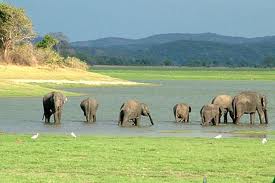
Highlands: The largest known 'Gathering' of Asian Elephants in the world occurs from May to October each year in Minneriya National Park

Friday, November 4, 2011

Gal Oya National Park


Gal Oya National Park in Sri Lanka was established in 1954 and serves as the main catchment area for Senanayake Samudraya, the largest reservoir in Sri Lanka. Senanayake Samudraya was built under the Gal Oya development project by damming the Gal Oya at Inginiyagala in 1950. An important feature of the Gal Oya National Park is its elephant herd that can be seen throughout the year. Three important herbs of the Ayurveda medicine, Triphala: Terminalia chebula, Terminalia bellirica and Emblica officinalis are amongst the notable flora of the forest. From 1954 to 1965 the park was administrated by the Gal Oya Development Board until theDepartment of Wildlife Conservation took over administration. The National Park is situated 314 km from Colombo.

Monday, October 10, 2011

Horton Plains


Horton Plains National Park is a protected area in the central highlands of Sri Lanka and is covered by montane grassland and cloud forest. This plateau at an altitude of 2,100–2,300 metres (6,900–7,500 ft) is rich in biodiversity and many species found here are endemic to the region. This region was designated a national park in 1988. It is also a popular tourist destination and is situated 32 kilometres (20 mi) from Nuwara Eliya.

The Horton Plains are the headwaters of three major Sri Lankan rivers, the Mahaweli, Kelani, and Walawe. In Sinhala the plains are known as Maha Eliya Plains. Stone tools dating back to Balangoda culture have been found here. The plains' vegetation is grasslands interspersed with montane forest, and includes many endemic woody plants. Large herds of Sri Lankan Sambar Deer feature as typical mammals, and the park is also an Important Bird Area with many species not only endemic to Sri Lanka but restricted to the Horton Plains. Forest dieback is one of the major threats to the park and some studies suggest that it is caused by a natural phenomenon. The sheer precipice of World's End and Baker's Falls are among the tourist attractions of the park.

Monday, September 5, 2011

Maduru Oya National Park


Maduru Oya National Park is located in the Dry zone and is 314 km away from Colombo It is situated by Kuda Sigiriya a great eco location yet to be explored by travelers to Sri Lanka.
Maduruoya well known for its elephant habitat. Other than elephant, leopard, sloth bear, sambhur, spotted and barking deer, wild boar and wild buffalo are also found here. Torque Macaque, Purple face leaf monkey and nocturnal slender Loris is also found in the park. Lesser Adjutant, Wooly necked stork, open bill, painted stork, Racket tailed Drongo, Yellow fronted barbet, Sri Lanka Junglefowl & Spurfowl are among the over 100 species of birds found within the park.
Ruins at Henanigala, Kudawila, Gurukumbura, Uluketangoda, Werapokuna and several other places include ancient Buddhist shrines, temples, dagobas, statues, devales and hermitages from different eras in Sri Lankan history. An ancient sluice dating prior to the 6th century BC was discovered recently on the old breached earthen bund of the Maduru Oya. Early Brahmin inscriptions dating from the 3rd century BC are found at Kandegamakanda. Vestiges of the Veddhas, an aboriginal tribe believed to be descended from King Vijaya and the Yaksha (demon) princess Kuveni, are to be traced in the traditional lifestyles of a few families in Dambana.  


Tuesday, August 9, 2011

Lunugamvehera National Park

Lunugamvehera National Park in Sri Lanka was declared in 1995, with the intention of protecting the catchment area of theLunugamvehera reservoir and wildlife of the area. The national park is an important habitat for water birds and elephants. The catchment area is vital to maintain the water levels of the five tanks in the down stream of Kirindi Oya and wetland characteristics ofBundala National Park. This national park also serves as a corridor for elephants to migrate between Yala National Park andUdawalawe National Park. The national park is situated 261 km (162 miles) southwest from Colombo. After being closed because of the Sri Lankan civil war, the national park is now open to the general public.

Friday, March 4, 2011

Proper documentation of the area begins with the Portuguese, the first European power to seize control of the maritime districts of Sri Lanka. During their administration from 1505 to 1656, t he Portuguese carefully compiled lists of villages so that the task of collecting taxes would be made easier. These lists (thombos) contained not merely names but detailed descriptions of the location and extent of each village as well as of the agricultural produce, including timber and fruit trees, fount there. The antiquity of certain village is made manifest in these Portuguese records for modern towns and villages in the Sinharaja region such as Kalawana and Pothupitiya still bear the same name they had when the Portuguese wrote about them four centuries ago.

Tuesday, January 18, 2011

Wasgamuwa National Park


Wasgamuwa National Park was originally declared as strict nature reserve in 1938 and then change to a national park in 1984. The park lies within central and north- central provinces. The total park area is 39,322 ha.

Wasgomuwa can be reached through Matale and Hettipola or from Dehiattakandiya coming from Polonnaruwa or from Mahiyangana.

Sunday, December 26, 2010

Wilpattu National park

Size131,693 hectares
Main attractionLeopards
Other Wildlife

Elephants, sloth bear , leopard water buffalo, and spotted deer, crocodile.


Situated 180 km from Colombo, and about 50 km from Anuradhapura Wilpattu National park is the largest wild life sanctuary in Sri Lanka. Declared as a sanctuary in 1938, and subsequently a national park, Wilpattu reserve, is a popular attraction for both tourists and wildlife enthusiasts

This park is packed with over 30 'vilas' or lakes and sandy tracks. Vila is defined as a natural depression generally circular with gently sloping banks - natural pool.

The park was closed in 1996 after LTTE Tiger Terrorists brutally murdered 26 of it employees. The park once again opened to the public in March 2003 after 18 years. During these 18 years the jungle was a heaven for the terrorists, poachers and illegal timber traders.

The park can be reached through Puttlam and is approximately 180 km from Colombo and Approximately 50 km from the ancient city of Anuradhapura. From Puttlam turn left to the Anuradhapura Road. The turnoff to the Wilpattu Entrance is close to the 43rd km post on this road. From this turn you need to travel about 10 km's on this road to reach entrance to the park.

If you are coming from Anuradhapura you need travel almost 40 km on the Anuradhapura - Puttlam road to the turn off.

Total
FromColomboToWattala
08
Negambo
35
Chillaw
80
Puttlam
132
FromPuttlamToWilpattu Junction
43
175
FromWilpattu Junction Wilpattu Entrance
10
185

Friday, April 30, 2010

Udawalawe National Park

Udawalawe National Park

The Udawalawe National Park situated in the dry zone of the country and belonging to Sabaragamuwa & Uva provinces. The park area is 30,821 ha. The park was established in 1972.

The park lies within dry zone and small segment lies within intermediate zone. The long dry season is characteristic feature. Main source of rainfall is southwest monsoon (May ? September) and mean annual rainfall is about 1520mm. the mean annual temperature is around 29?C.
Park consists of dry lowland forest, riverine forest, thorny scrublands and grasslands. One special attraction of the park is the Udawalawe reservoir and the Walawe River which flows through the park.


The main tree species found in the forest area are the satin (Chloroxylon swietenia), Milla (Vites pinata), ebony (Diospyros ebenum) and Ehala (Cassia fistula). Riverine forest dominated by Kumbuk (Terminalia arjuna) & Mandora (Hopea cordifolia). Mana (Cymbopogon confertiflorus), Illuk (Imperata cylindrica) and Daminiya (Grewia tiliaefolia) are found in grasslands & scrublands.

Friday, March 12, 2010

Kumana national park

Kumbukkan Oya forms the southern boundary of the national park. Some 20 lagoons and tanks support the extensive birdlife of the national park. The lagoons are shallow with depths less than 2 metres (6.6 ft). Kumana villu is subject to occasional inundation with seawater. The elevation of the area ranges from sea level to 90 metres (300 ft). The mean annual temperature is 27.30 °C (81.14 °F) and the area receives 1,300 millimetres (51.18 in) of annual rainfall
The park's wetland areas are surrounded by dry zone tropical thorn forest. The inland forest's flora is dominated by Manilkara hexandra (Sinhalese "Palu"), Hemicyclea sepieria, Bauhinia racemosa, Cassia fistula ("Ehela"), Chloroxylon swietenia ("Burutha"), and Salvadora persica species. The dominant tree of the Kumana villu is Sonneratia caseolaris, while Typh angustifolia is the dominant reed. Terminalia arjuna trees dominate the riverine forests along the Kumbukkan Oya. The common aquatic plants of the swamp are colourful Ludwigia spp., Nelumbo nucifera, Nymphaea pubescens, Aponogeton spp. and Neptunia oleracea.

Kumana Bird Sanctuary, declared in 1938, is included within the Kumana National Park. Kumana is one of the most important bird nesting and breeding grounds in Sri Lanka. 255 species of birds have been recorded in the national park. During April–July months tens of thousands of birds migrate to the Kumana swamp area annually. Rare species such as Black-necked Stork, Lesser Adjutant, Eurasian Spoonbill, and Great Thick-knee are breeding inhabitants of the Kumana villu. Waders belonging to families Scolopacidae and Charadriidae are among the visitors to the area along with waterfowl. Pintail Snipes migrate here flying 9,000 kilometres (5,600 mi) to 11,000 kilometres (6,800 mi) from Siberia. Asian Openbill, Glossy Ibis, Purple Heron, Great Egret, Indian Pond Heron, Black-crowned Night Heron, Intermediate Egret, Little Egret, Spot-billed Pelican, Indian Cormorant, Little Cormorant, Common Moorhen, Watercock, Purple Swamphen, White-breasted Waterhen, Pheasant-tailed Jacana, Lesser Whistling Duck and Little Grebe are the bird species migrate here in large flocks. Among the rare birds that migrate to the swap include Yellow-footed Green Pigeon, Greater Racket-tailed Drongo, Malabar Trogon, Red-faced Malkoha, and Sirkeer Malkoha. Pacific Golden Plover, Greater Sand Plover, Lesser Sand Plover, Grey Plover, Ruddy Turnstone, Little Ringed Plover, Wood Sandpiper, Marsh Sandpiper, Common Redshank, Common Sandpiper, Curlew Sandpiper, Little Stint, Common Snipe, and Pintail Snipe are the common wading birds of the park
The Kumana area is part of an ancient civilization that goes back to the 3rd century BC. Rock inscriptions belonging to the 2nd and 1st centuries BC have also been found in the region. The Kumana National Park lies on the route of the traditional annual foot Pilgrimage to the Hindu temple at Kataragama. Both Tamil and Sinhalese communities take part in this pilgrimage.
The number of birds observed in the national park has fallen in recent years. Environmentalists and wildlife lovers have expressed their concern over a road planned to be constructed from Kirinda to Panama which will run along the coastline of the park

Saturday, February 13, 2010

Bundala National Par


Bundala National Park is situated in the southeast part of the country in the semi arid zone. Park belongs to Southern Province. The park area is 6,216 hectares.

The park was initially established as a Sanctuary in 1969. Due to its significant role as a wintering site for migratory birds this was declared as RAMSAR wetland in 1990.

As Bundala National Park is located in semi arid zone, rainfall is highly seasonal. Main source of rainfall is Northeast monsoons (December – February). Mean Annual Rainfall: 900 – 1300 mm. Area is experiencing prolong drought from May to October. Mean annual Temperature 27o C. Daily temperature above 30oC is not uncommon.

Bundala National Park is mainly consist of 4 brackish lagoons, salt pans, marshes, thorny scrub lands, sand dunes, dry mixed ever green forests and dry grass lands.

Scrublands mainly consist of Andara (Dichrostachys cinerea), Eraminiya (Ziziphus sp.), Karamba (Carrisa spinarum). However the invasive species such as Prosopis juliflora and Opuntia delenii are spreading in the grasslands and scrublands.
Forest is covered by typical dominants of Dry mixed ever green forests Palu (Manilkara hexandra), Weera (Drypetes sepiaria) and Mallithan (Salvadora persica). Maila (Bauhinia racemosa) and diwul (Limonia acidissima) are also frequently seen.

Park provides the shelter for Elephant, Spotted Dear, Wild Boar, Black naped hare, Grey & Ruddy mongoose, toque macaque, Grey Langur & porcupine, jackal and fishing & Rusty Spotted cats. This park is also well known for sightings of estuarine crocodile and mugger crocodile.

The main attraction of the Bundala is the birdlife, especially waders. There are both resident and migratory species. Greater Flamingo, Spot-billed Pelican, Lesser Adjutant and Black-necked Stork are among the large birds. Large flocks of terns, gulls, sand-pipers, snipes, teals, cormorants, egrets and many more water birds are commonly seen.

Weerawila National Park

This dry zone sanctuary is mainly comprises with three lakes namely, Weerawila wewa, Debara wewa and Pannagamuwa wewa. Yodha wewa and Tissa wewa are another two lakes, which located little far away from above three lakes. All these lakes are act as ideal habitats for shorebirds.


Since they are situated close to south coast and Bundala National Park, which is the south most destination of the migratory birds of Sri Lanka lot of migratory birds also can be seen here. Egrets, Cormorants, Asian Openbill, White Ibis, Eurasian Spoonbill and many winter migrants can be seen here. Being the most prominent water resources in the area these tanks attracts considerable number of animals during the dry season. However the most common animal of the area is feral Buffalos.

Thursday, February 11, 2010

Udawalawe National Park

The Udawalawe National Park situated in the dry zone of the country and belonging to Sabaragamuwa & Uva provinces. The park area is 30,821 ha. The park was established in 1972.

The park lies within dry zone and small segment lies within intermediate zone. The long dry season is characteristic feature. Main source of rainfall is southwest monsoon (May ? September) and mean annual rainfall is about 1520mm. the mean annual temperature is around 29?C.
Park consists of dry lowland forest, riverine forest, thorny scrublands and grasslands. One special attraction of the park is the Udawalawe reservoir and the Walawe River which flows through the park.


The main tree species found in the forest area are the satin (Chloroxylon swietenia), Milla (Vites pinata), ebony (Diospyros ebenum) and Ehala (Cassia fistula). Riverine forest dominated by Kumbuk (Terminalia arjuna) & Mandora (Hopea cordifolia). Mana (Cymbopogon confertiflorus), Illuk (Imperata cylindrica) and Daminiya (Grewia tiliaefolia) are found in grasslands & scrublands.

Yala National Park

Yala National Park is situated in the southeast region of the island in the dry zone boarding the Indian Ocean. Park area is belonging to two provinces namely South and Uva Provinces. The total area of the park (which is of 5 blocks) is 97,881 ha but only Block I and Block II are open for visitors.

The park was initially established in 1938 only with block I and other blocks were included later.Rainfall is highly seasonal. Main source of rainfall is Northeast monsoons (December – February) and inter monsoonal rains during March-April. Mean Annual Rainfall: 900 – 1300 mm. Area is experiencing drought during June –October. Mean annual Temperature 27o C. Daily temperature above 30oC is not uncommon.Vegetation is mainly consists of Secondary lowland dry monsoon forest & semi arid thorny scrublands. Small patches of riverine forest, mangroves, sand dunes and dry grasslands also presented.
Forest area is dominated by Palu (Manilkara hexandra), Weera (Drypetes sepiaria), Malitthan (Salvadora persica), Ehala (Cassia fistula), Divul (Limonia acidissima) and Kohomba (Azadirachta indica). Thorny scrubland is dominated by Eraminia (Ziziphus.sp) and Andara (Dichrostachys cinerea). Sonneratia, Acanthus, Rhizopora and Lumnitzera species dominate the mangrove vegetation.

All the big game mammals of the country are found within the park. Elephant, Leopard, sloth bear, Spotted Dear, Wild Boar and sambhur. Apart from them small mammals such as Black naped hare, Grey, Ruddy & Striped necked mongoose, Grey Langur & porcupine are common small mammals.